Avalanche Warning Issued for New Zealand's Mid and North Island Due to Heavy Rainfall
Heavy rainfall forecast for New Zealand's mid and north Island regions triggers avalanche warning. Learn about the risks, affected areas, and safety measures.

Heavy rainfall forecast for New Zealand's mid and north Island regions triggers avalanche warning. Learn about the risks, affected areas, and safety measures.
New Zealand's mountainous regions in the mid and north Island are facing an elevated risk of avalanches due to a forecast of significant rainfall on Tuesday. Authorities have issued a warning urging caution, especially for those venturing into alpine terrain.
The primary concern is the combination of existing snowpack and the anticipated heavy rainfall. This saturation can weaken the snow's structural integrity, making it more prone to sliding. An avalanche occurs when a large mass of snow rapidly flows down a slope. These events can be incredibly dangerous, posing a serious threat to anyone in their path.
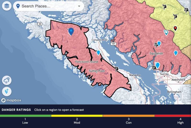
The avalanche risk is most pronounced in alpine areas of the mid and north Island. These are typically higher altitude regions known for their steep slopes and snow accumulation. Specific locations within these regions will likely experience varying levels of danger, depending on slope angle, aspect (direction the slope faces), and snowpack conditions.
The current avalanche danger is rated at Level 4, described as 'High'. This means that very dangerous avalanche conditions exist. Natural and human-triggered avalanches are likely. Travel in avalanche terrain is not recommended. This is a serious warning that should not be taken lightly.
Avalanches are a significant natural hazard in New Zealand's mountainous regions. This warning is crucial for several reasons:
In our opinion, this avalanche warning highlights the importance of monitoring weather patterns and understanding local terrain when engaging in outdoor activities in mountainous areas. The "High" danger level should serve as a significant deterrent for anyone considering venturing into avalanche terrain.
The interplay between weather patterns and snowpack stability is complex. Heavy rainfall introduces several destabilizing factors:
This combination of factors can dramatically increase the likelihood of avalanches. The Level 4 rating is a clear indication of the severity of the situation.
The immediate future depends heavily on the intensity and duration of the predicted rainfall. Continued monitoring of weather conditions and snowpack stability is essential. The avalanche risk will likely remain elevated until the rainfall subsides and the snowpack has a chance to stabilize.
This could impact future planning, especially for tour operators, guiding companies, and individuals relying on access to mountain areas for recreational or professional purposes. We anticipate continued updates from authorities regarding the evolving avalanche risk as the weather event unfolds. Continued communication and vigilance are vital for mitigating the potential risks associated with this situation.
It is essential to check with the New Zealand Avalanche Advisory (NZAA) for up-to-date information and specific warnings for your area before heading into the mountains. Always prioritize safety and make conservative decisions when avalanche danger is present.